| [3] |
Name on the Register |
Image |
Date listed[4] |
Location |
City or town |
Description |
|---|
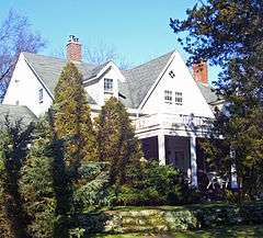
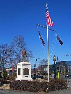
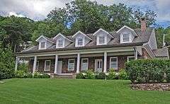
| 1 |
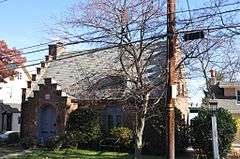
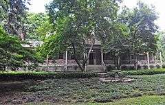
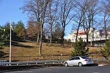
Maj. John Andre Monument |
|
000000002006-11-08-0000November 8, 2006
(#06001001) |
42 Andre Hill
41°01′17″N 73°57′19″W / 41.021389°N 73.955278°W / 41.021389; -73.955278 (Maj. John Andre Monument) |
Tappan |
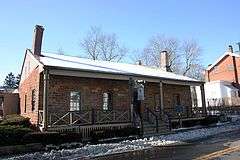
Site of Major John André's Hanging and Burial
|
| 2 |
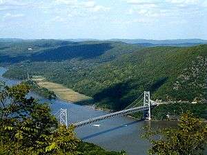
Bear Mountain Bridge |
|
000000001982-11-23-0000November 23, 1982
(#82001266) |
NY 6/202
41°19′12″N 73°58′49″W / 41.32°N 73.980278°W / 41.32; -73.980278 (Bear Mountain Bridge) |
Stony Point |
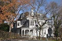
First crossing of Hudson north of New York City; built 1924 by Harriman family and later turned over to state
|
| 3 |
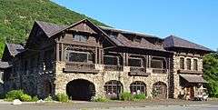
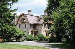
Bear Mountain Inn |
|
000000002002-09-20-0000September 20, 2002
(#02001048) |
Seven Lakes Drive
41°18′47″N 73°59′25″W / 41.313056°N 73.990278°W / 41.313056; -73.990278 (Bear Mountain Inn) |
Bear Mountain |
1915 rustic lodge was among first improvements to Bear Mountain State Park
|
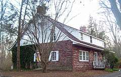
| 4 |
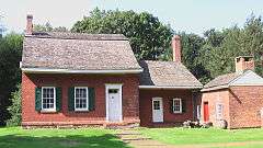
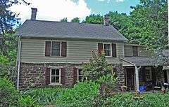
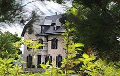
Big House |
|
000000001990-07-12-0000July 12, 1990
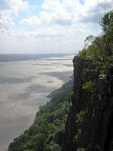
(#90001008) |
US 9W near the junction with Closter Rd.
41°00′45″N 73°54′47″W / 41.0125°N 73.913056°W / 41.0125; -73.913056 (Big House) |
Palisades |
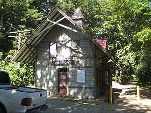
|
| 5 |
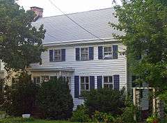
Blauvelt House |
|
000000001985-03-28-0000March 28, 1985
(#85000659) |
20 Zukor Rd.
41°10′16″N 73°59′13″W / 41.171°N 73.987°W / 41.171; -73.987 (Blauvelt House) |
New City |
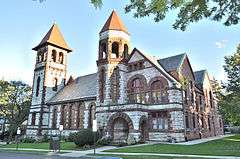
|
| 6 |
Brick Church Complex |
|
000000001984-09-07-0000September 7, 1984
(#84002947) |
Brick Church Rd. and NY 306
41°08′25″N 74°03′55″W / 41.140278°N 74.065278°W / 41.140278; -74.065278 (Brick Church Complex) |
New Hempstead |
|
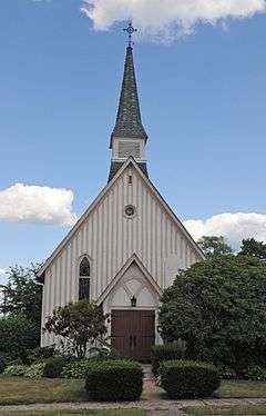
| 7 |
Brook Chapel |
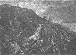
|
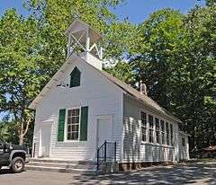
000000002010-02-14-0000February 14, 2010
(#09001287) |
6th St.
41°07′29″N 74°10′35″W / 41.124722°N 74.176389°W / 41.124722; -74.176389 (Brook Chapel) |
Hillburn |
|
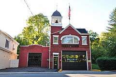
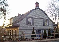
| 8 |
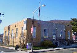
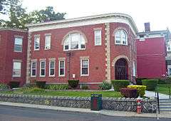
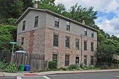
Brookside |
|
000000002012-07-10-0000July 10, 2012
(#12000408) |
406 N. Broadway
41°06′20″N 73°55′05″W / 41.10563°N 73.918163°W / 41.10563; -73.918163 (Brookside) |
Upper Nyack |
|
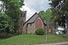
| 9 |
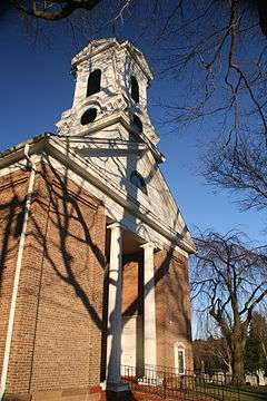
Christ Church |
|
000000002011-05-18-0000May 18, 2011
(#11000291) |
416 Valentine Ave.
41°01′48″N 73°55′34″W / 41.03°N 73.926111°W / 41.03; -73.926111 (Christ Church) |
Sparkill |
|
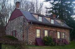
| 10 |
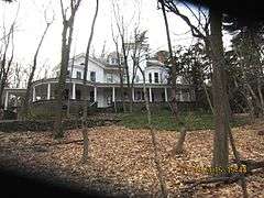
Cliffside |
|
000000001990-07-12-0000July 12, 1990
(#90001012) |
Lawrence Ln. south of River Rd.
41°00′28″N 73°54′14″W / 41.007778°N 73.903889°W / 41.007778; -73.903889 (Cliffside) |
Palisades |
|
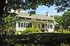
| 11 |
Closter Road-Oak Tree Road Historic District |
|
000000001990-07-12-0000July 12, 1990
(#90001014) |
Roughly, north side of Closter Rd. and south side of Oak Tree Rd. approximately 0.5 miles (0.80 km) west of US 9W
41°00′43″N 73°55′03″W / 41.011944°N 73.9175°W / 41.011944; -73.9175 (Closter Road-Oak Tree Road Historic District) |
Palisades |
|
| 12 |
Abner Concklin House |
|
000000001987-08-06-0000August 6, 1987
(#87001358) |
Closter Rd.
41°00′26″N 73°55′14″W / 41.007222°N 73.920556°W / 41.007222; -73.920556 (Abner Concklin House) |
Palisades |
|
| 13 |
Contempora House |
|
000000002009-04-29-0000April 29, 2009
(#09000260) |
88 S. Mountain Rd.
41°10′58″N 74°01′03″W / 41.182828°N 74.017481°W / 41.182828; -74.017481 (Contempora House) |
New City |
|
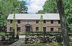
| 14 |
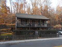
De Wint House |
|
000000001966-10-15-0000October 15, 1966
(#66000568) |
Livingston Ave. and Oak Tree Rd.
41°01′11″N 73°56′47″W / 41.019722°N 73.946389°W / 41.019722; -73.946389 (De Wint House) |
Tappan |
Oldest house in county.
Headquarters of George Washington: August 1780, September–October 1780, May 1783.
Site of John André spy trial during American Revolutionary War.
|
| 15 |
John A. DeBaun Mill |
|
000000001993-09-02-0000September 2, 1993
(#93000852) |
NY 59, N side, opposite Highview Ave.
41°06′45″N 74°06′16″W / 41.1125°N 74.104444°W / 41.1125; -74.104444 (John A. DeBaun Mill) |
Tallman |
|
| 16 |
Peter DePew House |
|
000000002008-07-03-0000July 3, 2008
(#08000596) |
101 Old Route 304
41°10′13″N 73°58′39″W / 41.170278°N 73.9775°W / 41.170278; -73.9775 (Peter DePew House) |
New City |
|
| 17 |
Dederer Stone House-Stonehurst |
|
000000002002-12-31-0000December 31, 2002
(#02001650) |
82 Rockland Rd.
41°01′53″N 73°55′20″W / 41.031389°N 73.922222°W / 41.031389; -73.922222 (Dederer Stone House-Stonehurst) |
Orangetown |
|
| 18 |
English Church and Schoolhouse |
|
000000001977-11-23-0000November 23, 1977
(#77000980) |
484 New Hempstead Rd.
41°08′59″N 74°01′58″W / 41.149722°N 74.032778°W / 41.149722; -74.032778 (English Church and Schoolhouse) |
New City |
1827 Federal-style church built for first English congregation established in New York west of Hudson a century earlier is second-oldest church in county. 1863 schoolhouse was in use as a public school building for over a century.
|
| 19 |
William Ferdon House |
|
000000002011-05-18-0000May 18, 2011
(#11000292) |
270 Ferdon Ave.
41°02′06″N 73°55′08″W / 41.035°N 73.918889°W / 41.035; -73.918889 (William Ferdon House) |
Piermont |
|
| 20 |
First Methodist Episcopal Church of Nyack |
|
000000001998-02-20-0000February 20, 1998
(#98000132) |
North Broadway, south of the junction of North Broadway and Birchwood Ave.
41°06′12″N 73°55′04″W / 41.103333°N 73.917778°W / 41.103333; -73.917778 (First Methodist Episcopal Church of Nyack) |
Upper Nyack |
|
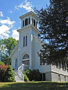
| 21 |
First Reformed Church |
|
000000002015-11-09-0000November 9, 2015
(#15000777) |
361 Ferdon Ave.
41°02′12″N 73°55′11″W / 41.0368012°N 73.9197852°W / 41.0368012; -73.9197852 (First Reformed Church) |
Piermont |
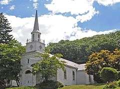
Wren-Gibbs Colonial Revival Church, built 1946, is home to oldest congregation in Piermont
|
| 22 |
Fraser-Hoyer House |
Upload image |
000000001976-04-22-0000April 22, 1976
(#76001270) |
Treason Hill off U.S. 9W
41°12′41″N 73°59′17″W / 41.211389°N 73.988056°W / 41.211389; -73.988056 (Fraser-Hoyer House) |
West Haverstraw |
|
| 23 |
Gurnee–Sherwood House |
|
000000002011-07-19-0000July 19, 2011
(#11000451) |
29 Spook Rock Road
41°09′34″N 74°05′48″W / 41.15957°N 74.09659°W / 41.15957; -74.09659 (Gurnee–Sherwood House) |
Wesley Hills |
|
| 24 |
Haddock's Hall |
|
000000001991-06-20-0000June 20, 1991
(#91000103) |
300 Ferdon Ave.
41°02′07″N 73°55′08″W / 41.035278°N 73.918889°W / 41.035278; -73.918889 (Haddock's Hall) |
Piermont |
|
| 25 |
Haring-Eberle House |
Upload image |
000000001990-07-12-0000July 12, 1990
(#90001010) |
US 9W north of Oak Tree Rd.
41°00′43″N 73°54′45″W / 41.011944°N 73.9125°W / 41.011944; -73.9125 (Haring-Eberle House) |
Palisades |
|
| 26 |
The Homestead |
|
000000001983-11-10-0000November 10, 1983
(#83004154) |
143 Hudson Ave.
41°11′36″N 73°58′00″W / 41.193333°N 73.966667°W / 41.193333; -73.966667 (The Homestead) |
Village of Haverstraw |
Farmhouse built ca. 1800 is one of oldest buildings in Haverstraw; residence of former mayor and other officials
|
| 27 |
Houser-Conklin House |
|
000000002010-10-01-0000October 1, 2010
(#10000808) |
246 Route 306
41°08′05″N 74°04′00″W / 41.134722°N 74.066667°W / 41.134722; -74.066667 (Houser-Conklin House) |
Monsey |
|
| 28 |
Edward Hopper Birthplace and Boyhood Home |
|
000000002000-04-06-0000April 6, 2000
(#00000352) |
82 North Broadway
41°05′35″N 73°55′06″W / 41.093056°N 73.918333°W / 41.093056; -73.918333 (Edward Hopper Birthplace and Boyhood Home) |
Nyack |
|
| 29 |
Hopson-Swan Estate |
|
000000001992-11-23-0000November 23, 1992
(#92001562) |
US 9W east of Sparkill, Tallman Mountain State Park
41°01′37″N 73°54′59″W / 41.026944°N 73.916389°W / 41.026944; -73.916389 (Hopson-Swan Estate) |
Sparkill |
|
| 30 |
Kings Daughters Public Library |
|
000000001991-08-09-0000August 9, 1991
(#91000950) |
Jct. of Main and Allison Sts.
41°11′47″N 73°57′39″W / 41.196389°N 73.960833°W / 41.196389; -73.960833 (Kings Daughters Public Library) |
Village of Haverstraw |
Recently renovated 1903 building was home to oldest chartered public library in county (now a branch)
|
| 31 |
Ladentown United Methodist Church |
|
000000002005-09-07-0000September 7, 2005
(#05000990) |
Ladentown Rd.
41°11′07″N 74°04′05″W / 41.185278°N 74.068056°W / 41.185278; -74.068056 (Ladentown United Methodist Church) |
Pomona |
|
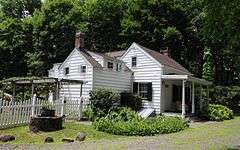
| 32 |
Little House |
|
000000001990-07-12-0000July 12, 1990
(#90001009) |
US 9W north of Oak Tree Rd.
41°00′43″N 73°54′45″W / 41.011944°N 73.9125°W / 41.011944; -73.9125 (Little House) |
Palisades |
|
| 33 |
M/V COMMANDER |
Upload image |
000000001984-09-27-0000September 27, 1984
(#84002951) |
Haverstraw Marina
41°13′52″N 73°58′32″W / 41.231111°N 73.975556°W / 41.231111; -73.975556 (M/V COMMANDER) |
Village of Haverstraw |
|
| 34 |
Main School |
|
000000002015-08-05-0000August 5, 2015
(#15000516) |
45 Mountain Ave.
41°07′30″N 74°10′11″W / 41.125002°N 74.169739°W / 41.125002; -74.169739 (Main School) |
Hillburn |
Early 20th century wooden school was site of New York's biggest school desegregation battle
|
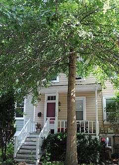
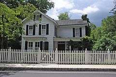
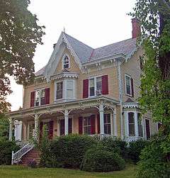
| 35 |
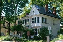
Carson McCullers House |
|
000000002006-07-14-0000July 14, 2006
(#06000562) |
131 S. Broadway
41°05′09″N 73°55′11″W / 41.0858°N 73.9197°W / 41.0858; -73.9197 (Carson McCullers House) |
South Nyack |
|
| 36 |
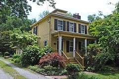
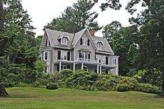
Robert W. and Mary F. McCready House |
Upload image |
000000002011-10-04-0000October 4, 2011
(#16000708) |
139 Orange Turnpike
41°09′51″N 74°11′34″W / 41.16425°N 74.19284°W / 41.16425; -74.19284 (Robert W. and Mary F. McCready House) |
Sloatsburg |
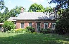
Eclectic 1889 Victorian home of Irish immigrant builder whose firm was instrumental in the development of Sloatsburg during that era
|
| 37 |
Mount Moor African-American Cemetery |
|
000000001994-08-29-0000August 29, 1994
(#94001001) |
Dexter Rd., off NY 59A
41°05′47″N 73°57′33″W / 41.0964°N 73.9592°W / 41.0964; -73.9592 (Mount Moor African-American Cemetery) |
West Nyack |
On the grounds of the Palisades Center mall.
|
| 38 |
Neiderhurst |
|
000000001990-07-12-0000July 12, 1990
(#90001011) |
Ludlow Ln. south of River Rd.
41°00′35″N 73°54′29″W / 41.009722°N 73.908056°W / 41.009722; -73.908056 (Neiderhurst) |
Palisades |
|
| 39 |
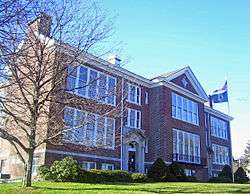
North Main Street School |
|
000000002008-02-28-0000February 28, 2008
(#08000105) |
185 N. Main St.
41°07′22″N 74°02′36″W / 41.122778°N 74.043333°W / 41.122778; -74.043333 (North Main Street School) |
Spring Valley |
One of the earliest modern school buildings in the county, built in 1916 and expanded several times since. Now a satellite campus of Rockland Community College.
|
| 40 |
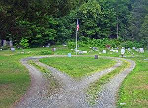
Old Sloatsburg Cemetery |
|
000000001999-07-23-0000July 23, 1999
(#99000807) |
Richards Rd.
41°09′13″N 74°11′48″W / 41.153611°N 74.196667°W / 41.153611; -74.196667 (Old Sloatsburg Cemetery) |
Sloatsburg |
Graves from late 18th to mid-20th centuries, including Sloat family members. Landscaping reflects different eras of cemetery design.
|
| 41 |
Onderdonk House |
|
000000002006-09-28-0000September 28, 2006
(#06000890) |
748 Piermont Ave.
41°02′51″N 73°55′09″W / 41.0475°N 73.919167°W / 41.0475; -73.919167 (Onderdonk House) |
Piermont |
|
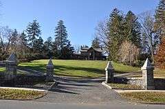
| 42 |
Palisades Interstate Park |
|
000000001966-10-15-0000October 15, 1966
(#66000890) |
W bank of the Hudson River
40°57′19″N 73°55′54″W / 40.955278°N 73.931667°W / 40.955278; -73.931667 (Palisades Interstate Park) |
Fort Lee |
Extends through several NY and NJ counties.
|
| 43 |
Henry M. Peck House |
Upload image |
000000002000-11-02-0000November 2, 2000
(#00001279) |
US 9W at Helen Hayes Hospital
41°12′44″N 73°59′18″W / 41.212222°N 73.988333°W / 41.212222; -73.988333 (Henry M. Peck House) |
West Haverstraw |
Destroyed by fire in 2002.
|
| 44 |
Jacob P. Perry House |
|
000000002003-07-03-0000July 3, 2003
(#03000594) |
15 Sickeletown Rd.
41°03′16″N 73°59′28″W / 41.054444°N 73.991111°W / 41.054444; -73.991111 (Jacob P. Perry House) |
Pearl River |
House dating from turn of 19th century is one of the last built in pre-Revolutionary Dutch Colonial style.
|
| 45 |
Philadelphia Toboggan Company Carousel Number 15 |
Upload image |
000000002001-06-08-0000June 8, 2001
(#01000583) |
1000 Palisades Center
41°05′48″N 73°57′22″W / 41.096667°N 73.956111°W / 41.096667; -73.956111 (Philadelphia Toboggan Company Carousel Number 15) |
West Nyack |
Formerly located in the Palisades Center but was removed in the summer of 2009.[5]
|
| 46 |
Piermont Railroad Station |
|
000000002008-12-03-0000December 3, 2008
(#08001146) |
50 Ash Street
41°02′30″N 73°55′06″W / 41.041539°N 73.918464°W / 41.041539; -73.918464 (Piermont Railroad Station) |
Piermont |
|
| 47 |
Henry Varnum Poor House |
Upload image |
000000002007-12-11-0000December 11, 2007
(#07001258) |
S. Mountain Rd.
41°11′01″N 74°00′59″W / 41.183611°N 74.016389°W / 41.183611; -74.016389 (Henry Varnum Poor House) |
New City |
|
| 48 |
House at 352 Piermont Avenue |
|
000000002015-01-27-0000January 27, 2015
(#14001218) |
352 Piermont Ave.
41°02′13″N 73°55′11″W / 41.037035°N 73.9196681°W / 41.037035; -73.9196681 (House at 352 Piermont Avenue) |
Piermont |
Well-preserved 1780 stone house is one of few of its design in county
|
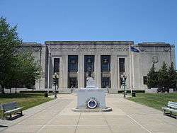
| 49 |
Rockland County Courthouse and Dutch Gardens |
|
000000001991-01-03-0000January 3, 1991
(#90002104) |
Jct. of S. Main St. and New Hempstead Rd.
41°08′47″N 73°59′27″W / 41.146389°N 73.990833°W / 41.146389; -73.990833 (Rockland County Courthouse and Dutch Gardens) |
New City |
|
| 50 |
Rockland Print Works |
|
000000002013-10-23-0000October 23, 2013
(#13000362) |
55 W. Railroad Ave.
41°12′32″N 73°59′32″W / 41.2089024°N 73.9921388°W / 41.2089024; -73.9921388 (Rockland Print Works) |
Garnerville |
Surviving factory complex from area's industrial past
|
| 51 |
Rockland Road Bridge |
|
000000002005-12-07-0000December 7, 2005
(#05001391) |
Rockland Rd., (bounded by Piermont and Ferdon Aves.)
41°02′06″N 73°55′10″W / 41.035°N 73.919444°W / 41.035; -73.919444 (Rockland Road Bridge) |
Piermont |
|
| 52 |
Rockland Road Bridge Historic District |
|
000000002011-09-29-0000September 29, 2011
(#11000709) |
Ferdon Ave., Rockland Rd. & S. Piermont Ave.
41°02′06″N 73°55′10″W / 41.035°N 73.919444°W / 41.035; -73.919444 (Rockland Road Bridge Historic District) |
Piermont |
|
| 53 |
William H. Rose House |
|
000000001999-04-15-0000April 15, 1999
(#99000459) |
110 Tomkin Ave.
41°14′00″N 73°59′04″W / 41.233333°N 73.984444°W / 41.233333; -73.984444 (William H. Rose House) |
Stony Point |
Picturesque house of local businessman built ca. 1862 moved from original nearby location
|
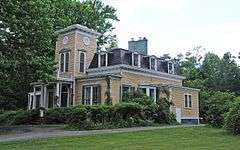
| 54 |
Ross-Hand Mansion |
|
000000001983-09-08-0000September 8, 1983
(#83001787) |
122 S. Franklin St.
41°05′12″N 73°55′23″W / 41.0867°N 73.9231°W / 41.0867; -73.9231 (Ross-Hand Mansion) |
South Nyack |
|
| 55 |
St. Paul's United Methodist Church |
|
000000002001-03-12-0000March 12, 2001
(#01000251) |
S. Broadway and Division St.
41°05′13″N 73°55′22″W / 41.086944°N 73.922778°W / 41.086944; -73.922778 (St. Paul's United Methodist Church) |
Nyack |
|
| 56 |
St. Paul's Episcopal Church |
|
000000002008-07-02-0000July 2, 2008
(#08000593) |
26 S. Madison Ave.
41°06′32″N 74°02′45″W / 41.108925°N 74.045886°W / 41.108925; -74.045886 (St. Paul's Episcopal Church) |
Spring Valley |
|
| 57 |
Edward Salyer House |
|
000000001986-09-04-0000September 4, 1986
(#86002178) |
241 S. Middletown Rd.
41°03′04″N 74°00′51″W / 41.051111°N 74.014167°W / 41.051111; -74.014167 (Edward Salyer House) |
Pearl River |
Rare surviving Dutch Colonial frame house, built in 1765. Believed to be oldest house in Pearl River.
|
| 58 |
Michael Salyer Stone House |
|
000000002002-12-31-0000December 31, 2002
(#02001654) |
Blue Hill Rd.
41°03′07″N 73°59′16″W / 41.051944°N 73.987778°W / 41.051944; -73.987778 (Michael Salyer Stone House) |
Orangetown |
1790 house has clapboard infill at gambrel roof's apex, much more common for Ulster County stone houses. May reflect Huguenot influence during construction.
|
| 59 |
Seaman–Knapp House |
|
000000002012-05-24-0000May 24, 2012
(#12000311) |
35 Ladentown Rd.
41°11′12″N 74°03′33″W / 41.186616°N 74.059163°W / 41.186616; -74.059163 (Seaman–Knapp House) |
Pomona |
|
| 60 |
Seven Oaks Estate |
|
000000001990-07-12-0000July 12, 1990
(#90001013) |
End of Ludlow Ln.
41°00′26″N 73°54′33″W / 41.007222°N 73.909167°W / 41.007222; -73.909167 (Seven Oaks Estate) |
Palisades |
|
| 61 |
Shadowcliff |
|
000000002014-04-07-0000April 7, 2014
(#14000131) |
521 N. Broadway
41°06′32″N 73°55′06″W / 41.1089285°N 73.9183376°W / 41.1089285; -73.9183376 (Shadowcliff) |
Upper Nyack |
|
| 62 |
Sloat House |
|
000000001974-11-05-0000November 5, 1974
(#74001301) |
19 Orange Tpke.
41°09′02″N 74°11′38″W / 41.150556°N 74.193889°W / 41.150556; -74.193889 (Sloat House) |
Sloatsburg |
Original 1755 home of Sloat family, added onto in 1810s. Has bullet holes from accidental shooting of John Sloat
|
| 63 |
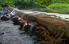
Sloat's Dam and Mill Pond |
|
000000002000-04-06-0000April 6, 2000
(#00000344) |
Off of Station Rd.
41°09′28″N 74°11′22″W / 41.157778°N 74.189444°W / 41.157778; -74.189444 (Sloat's Dam and Mill Pond) |
Sloatsburg |
Only surviving dam of three on the upper Ramapo River dates to 1792. Powered Jacob Sloat's mills; used until 1955
|
| 64 |
Jacob Sloat House |
|
000000002006-12-22-0000December 22, 2006
(#06001144) |
15 Liberty Rock Rd.
41°09′19″N 74°11′43″W / 41.155278°N 74.195278°W / 41.155278; -74.195278 (Jacob Sloat House) |
Sloatsburg |
Also known as Harmony Hall. 1848 retirement home of local textile merchant who gave village its name illustrates transition from Greek Revival to Picturesque in American architecture.
|
| 65 |
Sparkill Creek Drawbridge |
|
000000001985-03-28-0000March 28, 1985
(#85000658) |
Bridge St. over Sparkill Creek
41°02′14″N 73°54′58″W / 41.037222°N 73.916111°W / 41.037222; -73.916111 (Sparkill Creek Drawbridge) |
Piermont |
|
| 66 |
H. R. Stevens House |
|
000000002005-01-14-0000January 14, 2005
(#04001480) |
234 Congers Rd.
41°09′02″N 73°58′24″W / 41.150556°N 73.973333°W / 41.150556; -73.973333 (H. R. Stevens House) |
New City |
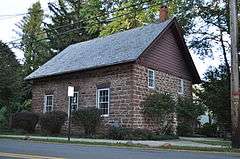
1775 house of locally quarried sandstone shows convergence of Dutch and English vernacular building traditions. Frame Federal style expansion done in 1820s.
|
| 67 |
Stony Point Battlefield |
|
000000001966-10-15-0000October 15, 1966
(#66000567) |
North of Stony Point on U.S. 9W and 202
41°14′32″N 73°58′25″W / 41.242222°N 73.973611°W / 41.242222; -73.973611 (Stony Point Battlefield) |
Stony Point |
|
| 68 |
Stony Point District School No. 4 |
|
000000002012-01-04-0000January 4, 2012
(#11001005) |
Central Dr. at Cedar Flats Rd.
41°14′16″N 74°01′17″W / 41.237814°N 74.021378°W / 41.237814; -74.021378 (Stony Point District School No. 4) |
Stony Point |
|
| 69 |
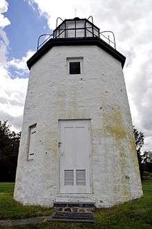
Stony Point Lighthouse |
|
000000001979-05-29-0000May 29, 1979
(#79001626) |
Stony Point Battlefield
41°14′29″N 73°58′20″W / 41.241389°N 73.972222°W / 41.241389; -73.972222 (Stony Point Lighthouse) |
Stony Point |
|
| 70 |
Tappan Historic District |
|
000000001990-04-26-0000April 26, 1990
(#90000689) |
Roughly bounded by Main St./Kings Hwy., Andre Ave. and New York Central RR
41°01′18″N 73°56′58″W / 41.021667°N 73.949444°W / 41.021667; -73.949444 (Tappan Historic District) |
Tappan |
|
| 71 |
Tappan Zee Playhouse |
Upload image |
000000001983-07-21-0000July 21, 1983
(#83001788) |
20 S. Broadway
41°05′24″N 73°55′09″W / 41.09°N 73.919167°W / 41.09; -73.919167 (Tappan Zee Playhouse) |
Nyack |
Demolished 2004.Cinema Treasures
|
| 72 |
Terneur-Hutton House |
|
000000001973-04-23-0000April 23, 1973
(#73001263) |
160 Sickelton Rd.
41°04′58″N 73°58′23″W / 41.0828°N 73.9731°W / 41.0828; -73.9731 (Terneur-Hutton House) |
West Nyack |
|
| 73 |
Torne Brook Farm |
|
000000001988-05-19-0000May 19, 1988
(#88000611) |
Torne Brook Rd.
41°08′25″N 74°09′48″W / 41.140278°N 74.163333°W / 41.140278; -74.163333 (Torne Brook Farm) |
Ramapo |
|
| 74 |
Upper Nyack Firehouse |
|
000000001982-09-23-0000September 23, 1982
(#82004781) |
330 N. Broadway
41°06′06″N 73°55′04″W / 41.101667°N 73.917778°W / 41.101667; -73.917778 (Upper Nyack Firehouse) |
Upper Nyack |
|
| 75 |
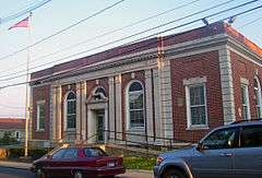
US Post Office-Haverstraw |
|
000000001988-11-17-0000November 17, 1988
(#88002497) |
86 Main St.
41°11′46″N 73°57′39″W / 41.196111°N 73.960833°W / 41.196111; -73.960833 (US Post Office-Haverstraw) |
Village of Haverstraw |
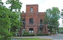
High level of ornament on 1934 building may be due to influence of native James Farley, then Postmaster General
|
| 76 |
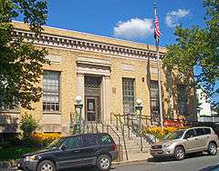
US Post Office-Nyack |
|
000000001989-05-11-0000May 11, 1989
(#88002387) |
48 S. Broadway
41°05′19″N 73°55′11″W / 41.088611°N 73.919722°W / 41.088611; -73.919722 (US Post Office-Nyack) |
Nyack |
Rare Classical Revival post office built after World War I
|
| 77 |
US Post Office-Pearl River |
|
000000001988-11-17-0000November 17, 1988
(#88002399) |
35 S. Main St.[6]
41°03′29″N 74°01′20″W / 41.058056°N 74.022222°W / 41.058056; -74.022222 (US Post Office-Pearl River) |
Pearl River |
Unique 1935 post office with highly restrained Colonial Revival design showing a strong modernist influence. Officially renamed in 2005 for local Vietnam War MIA
|
| 78 |
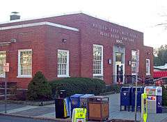
US Post Office-Spring Valley |
|
000000001989-05-11-0000May 11, 1989
(#88002432) |
7 N. Madison Ave.
41°06′47″N 74°02′46″W / 41.113056°N 74.046111°W / 41.113056; -74.046111 (US Post Office-Spring Valley) |
Spring Valley |
Colonial Revival design of 1936 post office, unique in state, emphasizes Greek Revival precedents of style
|
| 79 |
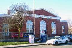
US Post Office-Suffern |
|
000000001989-05-11-0000May 11, 1989
(#88002435) |
15 Chestnut St.
41°06′59″N 74°09′10″W / 41.116389°N 74.152778°W / 41.116389; -74.152778 (US Post Office-Suffern) |
Suffern |
1930s building combining elements of Streamline Moderne and Colonial Revival styles; inside features relief of Communication as a semi-nude woman shooting a flaming arrow.
|
| 80 |
USCO Church |
Upload image |
000000002016-05-03-0000May 3, 2016
(#16000225) |
21 Church St.
41°12′24″N 73°59′42″W / 41.206792°N 73.995076°W / 41.206792; -73.995076 (USCO Church) |
Garnerville |
19th-century wooden former Methodist church used by late-1960s art collective USCO
|
| 81 |
Van Houten's Landing Historic District |
|
000000002004-08-20-0000August 20, 2004
(#04000877) |
North Broadway, School St., Ellen St., Castle Heights Ave., Van Houten St.
41°06′02″N 73°55′00″W / 41.100556°N 73.916667°W / 41.100556; -73.916667 (Van Houten's Landing Historic District) |
Upper Nyack |
|
| 82 |
Washington Avenue Soldier's Monument and Triangle |
|
000000002006-07-26-0000July 26, 2006
(#06000646) |
Washington Avenue Triangle (Jct. of Washington and Lafayette Aves.)
41°06′53″N 74°09′01″W / 41.114722°N 74.150278°W / 41.114722; -74.150278 (Washington Avenue Soldier's Monument and Triangle) |
Suffern |
Memorial to local World War I dead on site where Washington and Lafayette camped features small cannon left over from Revolution
|
| 83 |
Washington Spring Road-Woods Road Historic District |
|
000000001990-07-12-0000July 12, 1990
(#90001015) |
Roughly, area along Washington Spring Rd. from Highland Ave. to the Hudson River and north approximately 0.5 miles (0.80 km) along Woods Rd.
41°00′42″N 73°54′26″W / 41.011667°N 73.907222°W / 41.011667; -73.907222 (Washington Spring Road-Woods Road Historic District) |
Palisades |
|
| 84 |
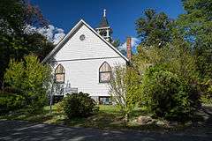
Former Wayside Chapel |
|
000000002000-04-06-0000April 6, 2000
(#00000346) |
24 River Rd.
41°04′24″N 73°55′14″W / 41.0733°N 73.9206°W / 41.0733; -73.9206 (Former Wayside Chapel) |
Grand View-on-Hudson |
|

.jpg)
.jpg)