National Register of Historic Places listings in Chemung County, New York

Location of Chemung County in New York
List of the National Register of Historic Places listings in Chemung County, New York
This is intended to be a complete list of properties and districts listed on the National Register of Historic Places in Chemung County, New York. The locations of National Register properties and districts (at least for all showing latitude and longitude coordinates below) may be seen in a map by clicking on "Map of all coordinates".[1] One site, the Newtown Battlefield, is further designated a National Historic Landmark.
- This National Park Service list is complete through NPS recent listings posted December 16, 2016.[2]
| Albany (Albany) – Allegany – Bronx – Broome – Cattaraugus – Cayuga – Chautauqua – Chemung – Chenango – Clinton – Columbia – Cortland – Delaware – Dutchess (Poughkeepsie, Rhinebeck) – Erie (Buffalo) – Essex – Franklin – Fulton – Genesee – Greene – Hamilton – Herkimer – Jefferson – Kings – Lewis – Livingston – Madison – Monroe (Rochester) – Montgomery – Nassau – New York (Below 14th Street, 14th to 59th Streets, 59th to 110th Streets, Above 110th Street, Islands) – Niagara – Oneida – Onondaga (Syracuse) – Ontario – Orange – Orleans – Oswego – Otsego – Putnam – Queens – Rensselaer – Richmond – Rockland – St. Lawrence – Saratoga – Schenectady – Schoharie – Schuyler – Seneca – Steuben – Suffolk – Sullivan – Tioga – Tompkins – Ulster – Warren – Washington – Wayne – Westchester (Northern, Southern, New Rochelle, Peekskill, Yonkers) – Wyoming – Yates |
Listings county-wide
| [3] | Name on the Register | Image | Date listed[4] | Location | City or town | Description |
|---|---|---|---|---|---|---|
| 1 | John Brand Jr. House | 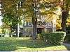 |
(#10000024) |
351 Maple Ave. 42°05′06″N 76°47′49″W / 42.084983°N 76.797053°W |
Elmira | |
| 2 | John Brand Sr. House | 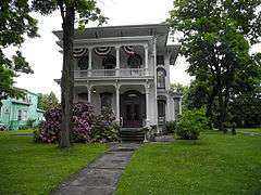 |
(#10000913) |
405 Maple Ave. 42°05′04″N 76°47′45″W / 42.084444°N 76.795833°W |
Elmira | |
| 3 | Buildings at 104-116 West Water St. | 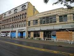 |
(#08001230) |
104-116 W. Water St. 42°05′17″N 76°48′19″W / 42.088047°N 76.805328°W |
Elmira | Demolished in 2014 and 2015 |
| 4 | Chemung Canal Bank Building | 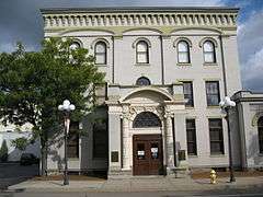 |
(#78001844) |
415 E. Water St. 42°05′18″N 76°48′01″W / 42.088333°N 76.800278°W |
Elmira | Built 1833; oldest commercial building in Elmira |
| 5 | Chemung County Courthouse Complex | 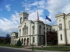 |
(#71000531) |
210-228 Lake St., between Market and E. Church Sts. 42°05′26″N 76°48′07″W / 42.090556°N 76.801944°W |
Elmira | Courthouse, District Attorney's and Treasurer's Building, County Clerk's Office and Courthouse Annex; built from 1836 through 1899 |
| 6 | Chemung District School No. 10 | 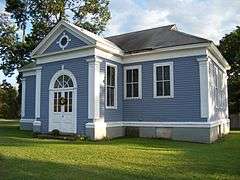 |
(#08000449) |
Old NY 17 at Lowman Rd. 42°01′44″N 76°42′56″W / 42.028889°N 76.715556°W |
Lowman | |
| 7 | Chemung Railway Depot-Horseheads | 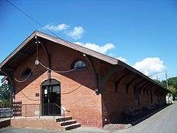 |
(#96001442) |
312 W. Broad St. 42°09′59″N 76°49′27″W / 42.166389°N 76.824167°W |
Horseheads | Built 1866; in use through 1956 |
| 8 | Clinton–Columbia Historic District | Upload image | (#15000308) |
505-605 College Ave., 300-431 W. Clinton, 608-612 Columbia, 348-354 W. 4th & 513-602 Davis Sts. 42°05′33″N 76°49′04″W / 42.092631°N 76.8177017°W |
Elmira | Residential area with many late 19th- and early 20th-century home built during Elmira's industrial boom |
| 9 | Warren E. Eaton Motorless Flight Facility | Upload image | (#13000778) |
62 Soaring Hill Dr. 42°07′18″N 76°54′05″W / 42.1217°N 76.9014°W |
Big Flats | Site of early development of American gliding |
| 10 | Christ Episcopal Church | 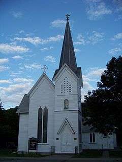 |
(#00000879) |
117 Main St. 42°00′54″N 76°43′39″W / 42.015°N 76.7275°W |
Wellsburg | Designed by Issac O. Perry; built in 1869 |
| 11 | Elmira Civic Historic District | 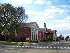 |
(#80002596) |
E. Church, Lake, E. Market, Baldwin, Carroll, and State Sts. 42°05′26″N 76°48′09″W / 42.090556°N 76.8025°W |
Elmira | Governmental center of early Elmira; includes Chemung County Courthouse Complex, U.S. Post Office, Armory Building and City Hall |
| 12 | Elmira Coca-Cola Bottling Company Works | 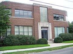 |
(#97000423) |
415 W. 2nd St. 42°05′21″N 76°48′58″W / 42.089167°N 76.816111°W |
Elmira | Art Moderne style building; built in 1939; significant for architecture and contribution to history of industry in Elmira |
| 13 | Elmira College Old Campus | 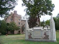 |
(#84002068) |
Roughly bounded by College and W. Washington Aves., N. Main St. and Park Pl. 42°05′52″N 76°48′53″W / 42.097778°N 76.814722°W |
Elmira | First college in the U.S. to have a degree program for women comparable to those at men's schools |
| 14 | Elmira Heights Village Hall | 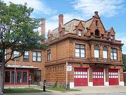 |
(#82003349) |
268 E. 14th St. 42°07′46″N 76°49′18″W / 42.129444°N 76.821667°W |
Elmira Heights | Built in 1896; designed by local architects Pierce and Bickford |
| 15 | Emmanuel Episcopal Church | 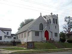 |
(#98001395) |
380 Pennsylvania Ave. 42°04′48″N 76°48′11″W / 42.08°N 76.803056°W |
Elmira | |
| 16 | Erste Deutsche Evangelische Kirche | 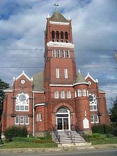 |
(#07001121) |
160 Madison Ave. 42°05′27″N 76°47′56″W / 42.090833°N 76.798889°W |
Elmira | Built 1898-1899; for German American congregation |
| 17 | Alexander Eustace House | 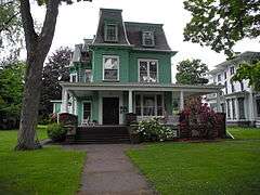 |
(#11000996) |
401 Maple Ave. 42°05′05″N 76°47′46″W / 42.084858°N 76.795989°W |
Elmira | |
| 18 | Dr. Hovey Everett House | 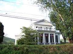 |
(#06001299) |
1594 Cty Rte 60 42°03′39″N 76°45′29″W / 42.060931°N 76.758153°W |
Lowman | |
| 19 | Fire Station No. 4 | 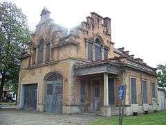 |
(#88000242) |
301 Maxwell Pl. 42°06′17″N 76°48′26″W / 42.104722°N 76.807222°W |
Elmira | Built in 1897; designed by local architects Pierce and Bickford |
| 20 | William S. Gerity House | 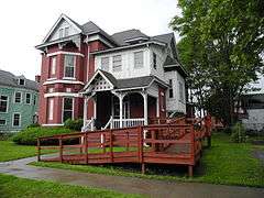 |
(#10000025) |
415 William St. 42°05′38″N 76°48′10″W / 42.093925°N 76.802692°W |
Elmira | |
| 21 | Hanover Square Historic District | 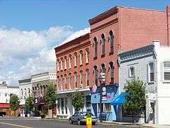 |
(#82001094) |
Jct. of E. and W. Franklin and N. and S. Main Sts. 42°10′03″N 76°49′16″W / 42.1675°N 76.821111°W |
Horseheads | Downtown business district; built mainly 1862-1882 after fire levelled town |
| 22 | Horseheads 1855 Extension Historic District | 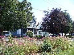 |
(#80002597) |
Grand Central Ave., Fletcher, Sayre, W. Mill and Center Sts. 42°09′46″N 76°49′14″W / 42.162778°N 76.820556°W |
Horseheads | |
| 23 | F. M. Howell and Company | 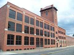 |
(#84002069) |
79-105 Pennsylvania Ave., 50 Pennsylvania Ave. 42°05′11″N 76°48′04″W / 42.086389°N 76.801111°W |
Elmira | |
| 24 | John W. Jones House | 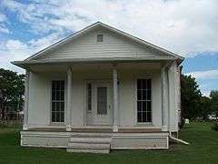 |
(#03001019) |
1250 Davis St. 42°06′27″N 76°49′26″W / 42.1075°N 76.823889°W |
Elmira | Home of former escaped slave, active abolitionist; worked with the Underground Railroad; sexton of Woodlawn Cemetery; buried Confederate dead |
| 25 | Maple Avenue Historic District | 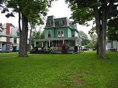 |
(#13000599) |
310 to 782 Maple (west side), 351 to 761 Maple (east side) 42°04′53″N 76°47′40″W / 42.08143°N 76.7944337°W |
Elmira | |
| 26 | Mount Saviour Monastery | Upload image | (#14001213) |
231, 121, 122 Monastery & 65, 212 Fisher Hill Rds 42°05′24″N 76°57′34″W / 42.0898883°N 76.9595233°W |
Pine City vicinity | Farm in continuous operation since 1865 demonstrates shift from large-scale cash crop production to smaller, sustainable specialty crops after purchase by monks in 1950 |
| 27 | Near Westside Historic District | 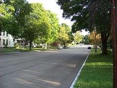 |
(#83003906) |
Roughly bounded by Chemung River, College Ave., 2nd and Hoffman Sts. 42°05′23″N 76°49′00″W / 42.089722°N 76.816667°W |
Elmira | |
| 28 | Newtown Battlefield | 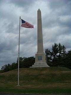 |
(#72000826) |
6 mi. SE of Elmira on NY 17 42°02′18″N 76°43′33″W / 42.038333°N 76.725833°W |
Elmira | Site of only major battle of the Sullivan Expedition; ordered by the Continental Congress to end the threat of the Iroquois ; the Iroquois were defeated decisively |
| 29 | North Main and West Water Commercial Historic District | Upload image | (#16000015) |
100-184 N. Main & 200-233 W. Water Sts. 42°05′15″N 76°48′27″W / 42.0876°N 76.8076°W |
Elmira | Business district reflecting city's westward expansion along trolley lines in late 19th-early 20th centuries |
| 30 | Park Church | 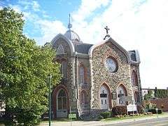 |
(#77000936) |
208 W. Gray St. 42°05′21″N 76°48′33″W / 42.089167°N 76.809167°W |
Elmira | |
| 31 | Pentecostal Holy Temple Church of Jesus Christ |  |
(#98001387) |
351 Division St. 42°06′26″N 76°48′31″W / 42.107222°N 76.808611°W |
Elmira | Address is currently an empty lot |
| 32 | Pratt House | 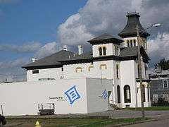 |
(#08001075) |
413 Lake St. 42°05′37″N 76°48′15″W / 42.093611°N 76.804167°W |
Elmira | |
| 33 | Quarry Farm |  |
(#75001177) |
Crane Rd. 42°06′37″N 76°46′58″W / 42.110278°N 76.782778°W |
Elmira | |
| 34 | Riverside Cemetery | 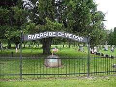 |
(#12000953) |
County Route 60 42°01′45″N 76°40′37″W / 42.029149°N 76.676826°W |
Lowman vicinity | |
| 35 | St. Patrick's Parochial Residence-Convent and School |  |
(#92001561) |
515-517 Park Pl. 42°05′36″N 76°48′40″W / 42.093333°N 76.811111°W |
Elmira | |
| 36 | Scotchtown Cemetery | 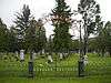 |
(#08001229) |
NY 223 42°10′36″N 76°41′55″W / 42.176767°N 76.698656°W |
Erin | |
| 37 | Teal Park | 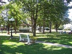 |
(#83003907) |
Steuben, Pine, and W. Main Sts. 42°09′51″N 76°49′11″W / 42.164167°N 76.819722°W |
Horseheads | Public greenspace; location of the Zim bandstand; designed by political cartoonist Eugene Zimmerman |
| 38 | Trinity Church | 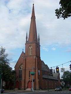 |
(#07001122) |
304 N. Main St. 42°05′24″N 76°48′30″W / 42.09°N 76.808333°W |
Elmira | Designed by Henry Dudley; built 1855-1858 |
| 39 | Woodlawn Cemetery and Woodlawn National Cemetery | 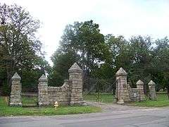 |
(#04001117) |
Walnut and Davis Sts., West Hill and Bancroft Rds. 42°06′36″N 76°49′40″W / 42.109971°N 76.827743°W |
Elmira | Burial place of Mark Twain, Ernie Davis, Hal Roach, John W. Jones; National portion begun with interment of Cofederate prisoners of war during the American Civil War |
| 40 | Zimmerman House | 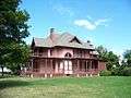 |
(#83003912) |
601 Pine St. 42°09′44″N 76°49′12″W / 42.162222°N 76.82°W |
Horseheads | Home of political cartoonist Eugene Zimmerman |
See also
| Wikimedia Commons has media related to National Register of Historic Places in Chemung County, New York. |
References
- ↑ The latitude and longitude information provided in this table was derived originally from the National Register Information System, which has been found to be fairly accurate for about 99% of listings. For about 1% of NRIS original coordinates, experience has shown that one or both coordinates are typos or otherwise extremely far off; some corrections may have been made. A more subtle problem causes many locations to be off by up to 150 yards, depending on location in the country: most NRIS coordinates were derived from tracing out latitude and longitudes off of USGS topographical quadrant maps created under the North American Datum of 1927, which differs from the current, highly accurate WGS84 GPS system used by most on-line maps. Chicago is about right, but NRIS longitudes in Washington are higher by about 4.5 seconds, and are lower by about 2.0 seconds in Maine. Latitudes differ by about 1.0 second in Florida. Some locations in this table may have been corrected to current GPS standards.
- ↑ "National Register of Historic Places: Weekly List Actions". National Park Service, United States Department of the Interior. Retrieved on December 16, 2016.
- ↑ Numbers represent an ordering by significant words. Various colorings, defined here, differentiate National Historic Landmarks and historic districts from other NRHP buildings, structures, sites or objects.
- ↑ The eight-digit number below each date is the number assigned to each location in the National Register Information System database, which can be viewed by clicking the number.
External links
- Chemung County, New York, listing, at National Register of Historic Places.Com
- Chemung Valley History Museum
| Topics |   | |
|---|---|---|
| Lists by county |
| |
| Lists by city | ||
| Other lists | ||
| ||
This article is issued from Wikipedia - version of the 10/6/2016. The text is available under the Creative Commons Attribution/Share Alike but additional terms may apply for the media files.