| [3] |
Name on the Register |
Image |
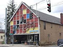
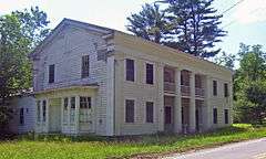
Date listed[4] |
Location |
City or town |
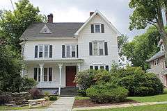
Description |
|---|
| 1 |
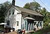
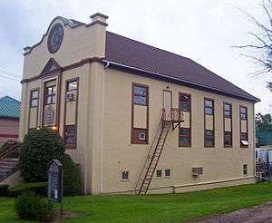
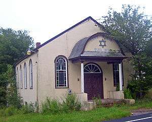
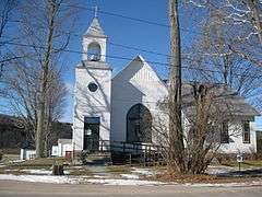
Anshei Glen Wild Synagogue |
|
000000001999-01-15-0000January 15, 1999
(#98001618) |
Glen Wild Road
41°39′00″N 74°35′20″W / 41.65°N 74.588889°W / 41.65; -74.588889 (Anshei Glen Wild Synagogue) |
Glen Wild |
1923 synagogue built and still owned by local family. Has never had its own rabbi.
|
| 2 |
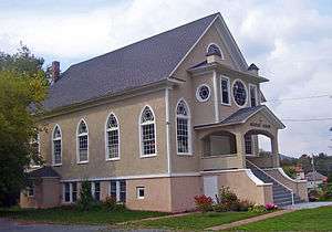
Agudas Achim Synagogue |
|
000000001998-11-19-0000November 19, 1998
(#98001404) |
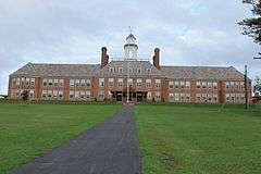
Rock Ave.
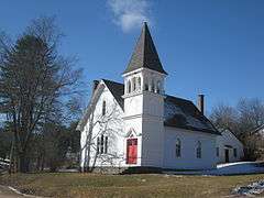
41°54′03″N 74°49′28″W / 41.900833°N 74.824444°W / 41.900833; -74.824444 (Agudas Achim Synagogue) |
Livingston Manor |
1924 synagogue built at unusual angle, shows influence of local churches with lancet arch windows
|
| 3 |
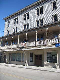
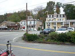
Arlington Hotel |
|
000000001983-03-31-0000March 31, 1983
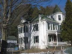
(#83001806) |
Main St.
41°36′30″N 75°03′40″W / 41.608333°N 75.061111°W / 41.608333; -75.061111 (Arlington Hotel) |
Narrowsburg |
|
| 4 |
B'nai Israel Synagogue |
Upload image |
000000001999-01-15-0000January 15, 1999
(#98001620) |
NY 52
41°45′09″N 73°48′31″W / 41.7525°N 73.8086°W / 41.7525; -73.8086 (B'nai Israel Synagogue) |
Woodbourne |
|
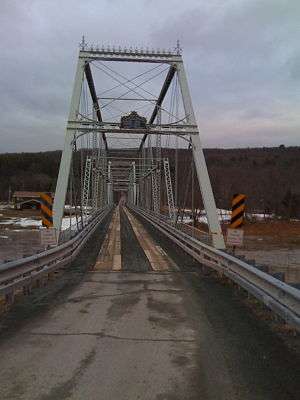
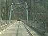
| 5 |
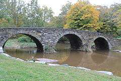
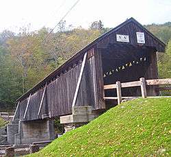
Beaverkill Covered Bridge |
|
000000002007-10-03-0000October 3, 2007
(#07001038) |
CR 30 over Beaverkill Cr.
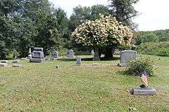
41°58′53″N 74°50′12″W / 41.981389°N 74.836667°W / 41.981389; -74.836667 (Beaverkill Covered Bridge) |
Beaverkill |
1865 covered bridge was one of earliest crossings of river in remote, unsettled area of Catskills. Some uncertainty as to who actually built it. Unusual variant on Ithiel Town-patented design.
|
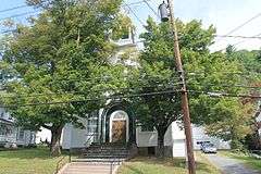
| 6 |
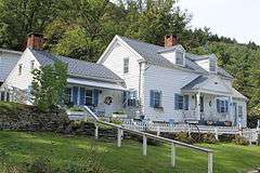
Bennett Family House |
|
000000002001-12-28-0000December 28, 2001
(#01001400) |
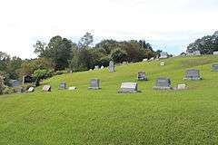
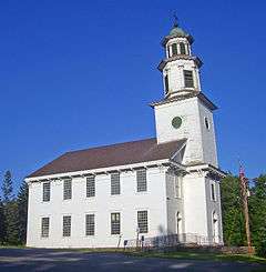
11 Hamilton Ave.
41°39′20″N 74°40′58″W / 41.655556°N 74.682778°W / 41.655556; -74.682778 (Bennett Family House) |
Monticello |
|
| 7 |
Bikur Cholim B'nai Israel Synagogue |
Upload image |
000000001999-01-15-0000January 15, 1999
(#98001619) |
Old White Lake Turnpike at NY 55
41°42′54″N 74°47′59″W / 41.715°N 74.799722°W / 41.715; -74.799722 (Bikur Cholim B'nai Israel Synagogue) |
Swan Lake |
|
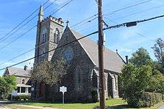
| 8 |
Bloomingburg Reformed Protestant Dutch Church |
|
000000001980-01-10-0000January 10, 1980
(#80002779) |
NY 17M
41°33′21″N 74°26′34″W / 41.555833°N 74.442778°W / 41.555833; -74.442778 (Bloomingburg Reformed Protestant Dutch Church) |
Bloomingburg |
1821 church is local landmark and one of the oldest churches in the county. Currently being prepared for use as a historical museum.
|
| 9 |
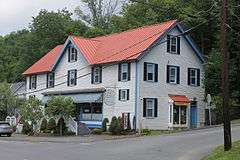
C. Burton Hotel |
|
000000002005-03-16-0000March 16, 2005
(#05000171) |
450 Main St.
41°51′11″N 74°33′09″W / 41.853056°N 74.5525°W / 41.853056; -74.5525 (C. Burton Hotel) |
Grahamsville |
1851 hotel is possibly the only surviving Greek Revival building in county with columns and a ballroom.
|
| 10 |
Ellery Calkins House |
|
000000001992-11-27-0000November 27, 1992
(#92001595) |
Co. Rd. 114, E of Delaware R. Bridge
41°42′27″N 75°03′50″W / 41.7075°N 75.063889°W / 41.7075; -75.063889 (Ellery Calkins House) |
Cochecton |
|
| 11 |
Callicoon Downtown Historic District |
|
000000002016-06-21-0000June 21, 2016
(#16000390) |
Main Sts, Highview & Mitchell Aves., River & Hospital Rds., Bridge St., and NY 97
Coordinates missing |
Callicoon |
Core of riverside community that grew up around 1848 railroad station
|
| 12 |
Callicoon Methodist Church and Parsonage |
|
000000001993-11-04-0000November 4, 1993
(#93001134) |
Church St. (NY 97) S of jct. with Seminary Rd., Town of Delaware
41°46′00″N 75°03′20″W / 41.766667°N 75.055556°W / 41.766667; -75.055556 (Callicoon Methodist Church and Parsonage) |
Callicoon |
|
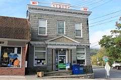
| 13 |
Callicoon National Bank |
|
000000001994-02-18-0000February 18, 1994
(#94000048) |
133 Main St.
41°45′58″N 75°03′32″W / 41.766111°N 75.058889°W / 41.766111; -75.058889 (Callicoon National Bank) |
Callicoon |
|
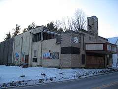
| 14 |
Center Theatre |
|
000000002001-02-23-0000February 23, 2001
(#01000170) |
NY 52
41°45′30″N 74°36′08″W / 41.758333°N 74.602222°W / 41.758333; -74.602222 (Center Theatre) |
Woodbourne |
|
| 15 |
Chevro Ahavath Zion Synagogue |
Upload image |
000000001999-01-28-0000January 28, 1999
(#98001621) |
Cold Spring Rd.
41°36′42″N 74°40′38″W / 41.611667°N 74.677222°W / 41.611667; -74.677222 (Chevro Ahavath Zion Synagogue) |
Monticello |
|
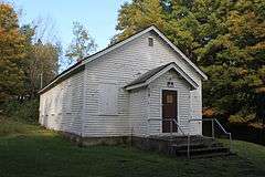
| 16 |
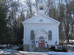
Cochecton Center Methodist Episcopal Church |
|
000000002000-04-21-0000April 21, 2000
(#00000343) |
Skipperdine Rd.
41°39′21″N 74°59′05″W / 41.655833°N 74.984722°W / 41.655833; -74.984722 (Cochecton Center Methodist Episcopal Church) |
Cochecton Center |
|
| 17 |
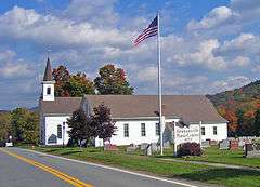
Cochecton Presbyterian Church |
|
000000001992-11-27-0000November 27, 1992
(#92001597) |
Co. Rd. 114, E of Delaware R. Bridge
41°42′25″N 75°03′52″W / 41.706944°N 75.064444°W / 41.706944; -75.064444 (Cochecton Presbyterian Church) |
Cochecton |
|
| 18 |
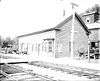
Cochecton Railroad Station |
|
000000002005-03-16-0000March 16, 2005
(#05000172) |
NY 97
41°43′04″N 75°02′46″W / 41.717778°N 75.046111°W / 41.717778; -75.046111 (Cochecton Railroad Station) |
Cochecton |
|
| 19 |
Delaware and Hudson Canal |
|
000000001968-11-24-0000November 24, 1968
(#68000051) |
Delaware and Hudson Canal
Coordinates missing |
Minisink |
|
| 20 |
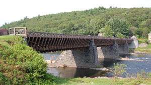
Delaware Aqueduct |
|
000000001968-11-24-0000November 24, 1968
(#68000055) |
Between Minisink Ford, NY and Lackawaxen, PA
41°28′57″N 74°58′37″W / 41.4825°N 74.976944°W / 41.4825; -74.976944 (Delaware Aqueduct) |
Minisink Ford |
Oldest wire suspension bridge in the U.S.; design precedent for Brooklyn Bridge; extends into Pike County, Pennsylvania
|
| 21 |
Drake-Curtis House |
|
000000001993-04-19-0000April 19, 1993
(#92001598) |
Co. Rd. 114, E of NY 97
41°42′32″N 75°03′06″W / 41.708889°N 75.051667°W / 41.708889; -75.051667 (Drake-Curtis House) |
Cochecton |
|
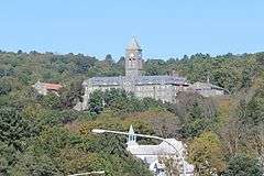
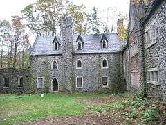
| 22 |
Dundas Castle |
|
000000002001-03-21-0000March 21, 2001
(#01000245) |
Berry Brook Rd.
41°58′46″N 74°52′38″W / 41.979444°N 74.877222°W / 41.979444; -74.877222 (Dundas Castle) |
Roscoe |
(be sure to link in article to Dundas Castle in Edinburgh, Scotland)
|
| 23 |
Ferndale School |
|
000000002005-01-05-0000January 5, 2005
(#04001437) |
Upper Ferndale Rd. and Ferndale Loomis Rd.
41°46′36″N 74°44′29″W / 41.776667°N 74.741389°W / 41.776667; -74.741389 (Ferndale School) |
Ferndale |
|
| 24 |
First Methodist Episcopal Church of Parksville |
|
000000002001-05-30-0000May 30, 2001
(#01000575) |
10 Short Ave.
41°51′21″N 74°45′32″W / 41.855833°N 74.758889°W / 41.855833; -74.758889 (First Methodist Episcopal Church of Parksville) |
Parksville |
|
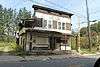
| 25 |
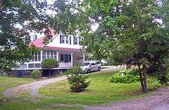
Forestburgh Town Hall |
|
000000002011-05-11-0000May 11, 2011
(#11000278) |
305 County Road 48
41°32′28″N 74°43′30″W / 41.541111°N 74.725°W / 41.541111; -74.725 (Forestburgh Town Hall) |
Forestburgh vicinity |
New listing; refnum 11000278
|
| 26 |
German Presbyterian Church and Hortonville Cemetery |
|
000000002003-01-15-0000January 15, 2003
(#02001712) |
CR 121 and CR 131
41°46′21″N 75°01′42″W / 41.7725°N 75.028333°W / 41.7725; -75.028333 (German Presbyterian Church and Hortonville Cemetery) |
Hortonville |
|
| 27 |
Glen Wild Methodist Church |
Upload image |
000000001984-05-10-0000May 10, 1984
(#84003035) |
Old Glen Wild Rd.
41°39′58″N 74°35′18″W / 41.666111°N 74.588333°W / 41.666111; -74.588333 (Glen Wild Methodist Church) |
Glen Wild |
|
| 28 |
Grahamsville Historic District |
|
000000001979-12-06-0000December 6, 1979
(#79001634) |
NY 55
41°50′48″N 74°32′19″W / 41.846667°N 74.538611°W / 41.846667; -74.538611 (Grahamsville Historic District) |
Grahamsville |
Intact core of 19th-century Grahamsville, east of present hamlet's downtown, with buildings mostly intact
|
| 29 |
Greenfield Preparative Meeting House |
Upload image |
000000002010-11-29-0000November 29, 2010
(#10000956) |
NY 55 at Denman Mountain Road
41°51′16″N 74°33′16″W / 41.854444°N 74.554444°W / 41.854444; -74.554444 (Greenfield Preparative Meeting House) |
Grahamsville |
New listing; refnum 10000956
|
| 30 |
Hankins District No. One Schoolhouse |
Upload image |
000000002000-02-04-0000February 4, 2000
(#00000054) |
Sullivan Cty Rd. 132
41°48′59″N 75°04′58″W / 41.816389°N 75.082778°W / 41.816389; -75.082778 (Hankins District No. One Schoolhouse) |
Hankins |
|
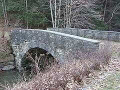
| 31 |
Hankins Stone Arch Bridge |
|
000000002000-07-27-0000July 27, 2000
(#00000838) |
Sullivean Cty. Rd. 94, E.
41°48′59″N 75°05′31″W / 41.816389°N 75.091944°W / 41.816389; -75.091944 (Hankins Stone Arch Bridge) |
Hankins |
|
| 32 |
Hart House |
Upload image |
000000002006-01-18-0000January 18, 2006
(#05001535) |
50 Hamilton St.
41°35′14″N 74°22′50″W / 41.587222°N 74.380556°W / 41.587222; -74.380556 (Hart House) |
Burlingham |
|
| 33 |
Hebrew Congregation of Mountaindale Synagogue |
|
000000002001-05-30-0000May 30, 2001
(#01000578) |
NY 55
41°41′18″N 74°31′51″W / 41.688333°N 74.530833°W / 41.688333; -74.530833 (Hebrew Congregation of Mountaindale Synagogue) |
Mountaindale |
1917 synagogue is only one in county with its own mikvah
|
| 34 |
Hessinger Store |
Upload image |
000000002000-06-02-0000June 2, 2000
(#00000584) |
Main St. (Co. Rd. 122)
41°50′10″N 74°56′51″W / 41.836111°N 74.9475°W / 41.836111; -74.9475 (Hessinger Store) |
Callicoon Center |
|
| 35 |
Jeffersonville School |
|
000000001988-04-28-0000April 28, 1988
(#88000519) |
Terrace Ave.
41°46′48″N 74°56′25″W / 41.78°N 74.940278°W / 41.78; -74.940278 (Jeffersonville School) |
Jeffersonville |
|
| 36 |
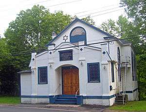
Jewish Center of Lake Huntington |
Upload image |
000000002009-12-11-0000December 11, 2009
(#09001087) |
13 County Road 116
41°46′48″N 74°56′25″W / 41.78°N 74.940278°W / 41.78; -74.940278 (Jewish Center of Lake Huntington) |
Lake Huntington |
New listing; refnum 09001087
|
| 37 |
Jewish Community Center of White Sulphur Springs |
Upload image |
000000001999-08-12-0000August 12, 1999
(#99000991) |
Briscoe Rd.
41°47′56″N 74°49′52″W / 41.798889°N 74.831111°W / 41.798889; -74.831111 (Jewish Community Center of White Sulphur Springs) |
White Sulphur Springs |
|
| 38 |
Kirk House |
Upload image |
000000001984-05-10-0000May 10, 1984
(#84003043) |
Kirk's Rd.
41°36′27″N 75°03′26″W / 41.6075°N 75.057222°W / 41.6075; -75.057222 (Kirk House) |
Narrowsburg |
|
| 39 |
Levitz Family Farm |
Upload image |
000000002002-01-24-0000January 24, 2002
(#01001497) |
395 Beaver Dam Rd.
41°47′51″N 74°32′00″W / 41.7975°N 74.533333°W / 41.7975; -74.533333 (Levitz Family Farm) |
Grahamsville |
|
| 40 |
Liberty Downtown Historic District |
|
000000002006-05-26-0000May 26, 2006
(#06000266) |
Main, Chestnut, Academy, School, Church, Maple, John, Edgar Sts., and Darbee Ln.
41°48′03″N 74°44′48″W / 41.800833°N 74.746667°W / 41.800833; -74.746667 (Liberty Downtown Historic District) |
Liberty |
|
| 41 |
Liberty Village Historic District |
|
000000001978-04-11-0000April 11, 1978
(#78001921) |
N. Main, Academy, and Law Sts.
41°48′05″N 74°44′53″W / 41.801389°N 74.748056°W / 41.801389; -74.748056 (Liberty Village Historic District) |
Liberty |
|
| 42 |
Loch Sheldrake Synagogue |
|
000000001997-08-12-0000August 12, 1997
(#97000844) |
NY 52, N of jct. of NY 52 and Loch Sheldrake Rd.
41°46′15″N 74°39′29″W / 41.770833°N 74.658056°W / 41.770833; -74.658056 (Loch Sheldrake Synagogue) |
Loch Sheldrake |
|
| 43 |
Mamakating Park Historic District |
|
000000001998-11-19-0000November 19, 1998
(#98001393) |
Roughly along Park Rd, Columbian Rd., and Mamakating Ave.
41°36′45″N 74°32′12″W / 41.6125°N 74.536667°W / 41.6125; -74.536667 (Mamakating Park Historic District) |
Wurtsboro |
1890s Catskill ridgetop resort community, never fully realized
|
| 44 |
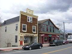
Manion's General Store |
|
000000002004-04-15-0000April 15, 2004
(#04000285) |
52 Ferndale Rd.
41°46′26″N 74°44′22″W / 41.773889°N 74.739444°W / 41.773889; -74.739444 (Manion's General Store) |
Ferndale |
|
| 45 |
Anthony Manny House |
Upload image |
000000002000-09-15-0000September 15, 2000
(#00000840) |
6 Hankins Rd.
41°48′53″N 75°05′15″W / 41.814722°N 75.0875°W / 41.814722; -75.0875 (Anthony Manny House) |
Hankins |
|
| 46 |
Masten-Quinn House |
|
000000002003-02-13-0000February 13, 2003
(#03000046) |
59 First St.
41°34′37″N 74°28′52″W / 41.576944°N 74.481111°W / 41.576944; -74.481111 (Masten-Quinn House) |
Wurtsboro |
1820s house of early farmer who took advantage of D&H Canal route through his land. Farmed until mid-20th century.
|
| 47 |
Milanville-Skinners Falls Bridge |
|
000000001988-11-14-0000November 14, 1988
(#88002167) |
Legislative Route 63027 over the Delaware River at Milanville
41°40′10″N 75°03′31″W / 41.669444°N 75.058611°W / 41.669444; -75.058611 (Milanville-Skinners Falls Bridge) |
Skinners Falls |
Extends into Damascus Township in Wayne County, Pennsylvania
|
| 48 |
Minisink Battlefield |
|
000000001993-09-16-0000September 16, 1993
(#93000946) |
Minisink Battleground Road (Co. Rd. 168) N of Minisink Ford
41°29′15″N 74°58′19″W / 41.4875°N 74.971944°W / 41.4875; -74.971944 (Minisink Battlefield) |
Minisink Ford |
Location of the Battle of Minisink during the American Revolution
|
| 49 |
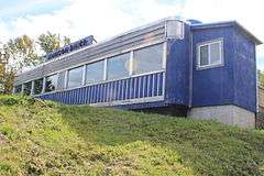
Munson Diner |
|
000000002006-04-12-0000April 12, 2006
(#06000256) |
Lake St. (NY 55)
41°47′47″N 74°44′46″W / 41.796389°N 74.746111°W / 41.796389; -74.746111 (Munson Diner) |
Liberty |
|
| 50 |
Narrowsburg Methodist Church |
|
000000002000-02-04-0000February 4, 2000
(#00000053) |
Lake St.
41°36′18″N 75°03′45″W / 41.605°N 75.0625°W / 41.605; -75.0625 (Narrowsburg Methodist Church) |
Narrowsburg |
|
| 51 |
Ohave Shalom Synagogue |
|
000000002000-11-22-0000November 22, 2000
(#00001412) |
Mauric Rose St.
41°42′38″N 74°34′23″W / 41.710556°N 74.573056°W / 41.710556; -74.573056 (Ohave Shalom Synagogue) |
Woodridge |
1930 synagogue combines urban and Eastern European design traditions. Interior paintings are unique in county
|
| 52 |
Old Cochecton Cemetery |
|
000000001992-11-27-0000November 27, 1992
(#92001593) |
W of NY 97, N of jct. with Co. Rd. 114
41°42′40″N 75°02′58″W / 41.711111°N 75.049444°W / 41.711111; -75.049444 (Old Cochecton Cemetery) |
Cochecton |
|
| 53 |
Page House |
Upload image |
000000001992-11-27-0000November 27, 1992
(#92001601) |
59 C. Meyer Rd.
41°41′01″N 75°02′53″W / 41.683611°N 75.048056°W / 41.683611; -75.048056 (Page House) |
Cochecton |
|
| 54 |
Parsonage Road Historic District |
|
000000001992-11-27-0000November 27, 1992
(#92001600) |
Parsonage Rd.
41°42′31″N 75°03′40″W / 41.708611°N 75.061111°W / 41.708611; -75.061111 (Parsonage Road Historic District) |
Cochecton |
|
| 55 |
Pond Eddy Bridge |
|
000000001988-11-14-0000November 14, 1988
(#88002170) |
LR 51013 over the Delaware River
41°26′21″N 74°49′13″W / 41.439167°N 74.820278°W / 41.439167; -74.820278 (Pond Eddy Bridge) |
Lumberland |
Extends into Pike County, Pennsylvania
|
| 56 |
Reilly's Store |
|
000000001992-11-27-0000November 27, 1992
(#92001594) |
Co. Rd. 114, W of jct. with NY 97
41°42′30″N 75°03′45″W / 41.708333°N 75.0625°W / 41.708333; -75.0625 (Reilly's Store) |
Cochecton |
|
| 57 |
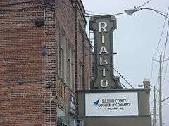
Rialto Theatre |
|
000000002001-02-02-0000February 2, 2001
(#01000043) |
Broadway
41°39′20″N 74°41′17″W / 41.655556°N 74.688056°W / 41.655556; -74.688056 (Rialto Theatre) |
Monticello |
|
| 58 |
Riverside Cemetery |
Upload image |
000000001993-11-18-0000November 18, 1993
(#93001226) |
NY 97 SE of jct. with Church St.
41°50′50″N 75°07′36″W / 41.847222°N 75.126667°W / 41.847222; -75.126667 (Riverside Cemetery) |
Long Eddy |
|
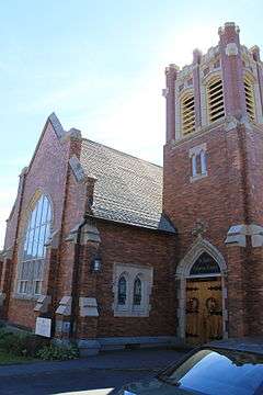
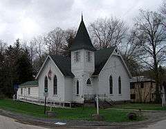
| 59 |
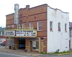
Rivoli Theatre |
|
000000002001-01-26-0000January 26, 2001
(#00001691) |
Jct. of NY 42 and Laurel Ave.
41°41′56″N 74°38′15″W / 41.698889°N 74.6375°W / 41.698889; -74.6375 (Rivoli Theatre) |
South Fallsburg |
1923 theater, renovated in Art Deco style in 1937. Preserved nearly intact and still used by local theater group
|
| 60 |
Rockland Mill Complex |
Upload image |
000000001984-08-23-0000August 23, 1984
(#84003062) |
Palen Pl.
41°56′56″N 74°54′52″W / 41.948889°N 74.914444°W / 41.948889; -74.914444 (Rockland Mill Complex) |
Rockland |
|
| 61 |
Roscoe Presbyterian Church and Westfield Flats Cemetery |
|
000000002001-06-08-0000June 8, 2001
(#01000574) |
Old NY 17
41°55′56″N 74°54′47″W / 41.932222°N 74.913056°W / 41.932222; -74.913056 (Roscoe Presbyterian Church and Westfield Flats Cemetery) |
Roscoe |
|
| 62 |
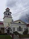
St. James Church and Rectory |
|
000000001993-11-04-0000November 4, 1993
(#93001135) |
NY 17B N side, E of jct. with NY 97, Town of Delaware
41°45′54″N 75°03′11″W / 41.765°N 75.053056°W / 41.765; -75.053056 (St. James Church and Rectory) |
Callicoon |
|
| 63 |
St. John's Episcopal Church and Rectory |
|
000000002002-11-21-0000November 21, 2002
(#02001359) |
15 St. John's St.
41°39′12″N 74°41′12″W / 41.653333°N 74.686667°W / 41.653333; -74.686667 (St. John's Episcopal Church and Rectory) |
Monticello |
|
| 64 |
St. Joseph's Seminary |
|
000000001993-07-08-0000July 8, 1993
(#93000582) |
Seminary Rd. W side
41°46′12″N 75°03′29″W / 41.77°N 75.058056°W / 41.77; -75.058056 (St. Joseph's Seminary) |
Callicoon |
|
| 65 |
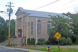
St. Paul's Evangelical Lutheran Church |
|
000000001997-08-15-0000August 15, 1997
(#97000845) |
24 Chestnut St.
41°47′56″N 74°44′50″W / 41.798889°N 74.747222°W / 41.798889; -74.747222 (St. Paul's Evangelical Lutheran Church) |
Liberty |
|
| 66 |
Shelburne Playhouse |
Upload image |
000000002004-04-15-0000April 15, 2004
(#04000284) |
Upper Ferndale Rd.
41°46′38″N 74°44′25″W / 41.777222°N 74.740278°W / 41.777222; -74.740278 (Shelburne Playhouse) |
Ferndale |
|
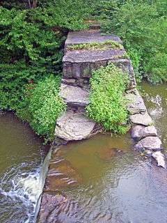
| 67 |
Silver Lake Dam |
|
000000002000-06-02-0000June 2, 2000
(#00000585) |
Silver Lake Rd.
41°42′06″N 74°33′03″W / 41.701667°N 74.550833°W / 41.701667; -74.550833 (Silver Lake Dam) |
Woodridge |
1840s dam built to regulate Sandburg Creek for summit section of D&H Canal created Silver Lake, later recreational resource.
|
| 68 |
South Fallsburg Hebrew Association Synagogue |
|
000000002000-11-22-0000November 22, 2000
(#00001410) |
North St.
41°42′25″N 74°37′51″W / 41.706944°N 74.630833°W / 41.706944; -74.630833 (South Fallsburg Hebrew Association Synagogue) |
South Fallsburg |
Originally built in 1902, is one of oldest synagogues in county. Has full sukkah in basement.
|
| 69 |
Spring House |
|
000000002009-12-02-0000December 2, 2009
(#09000970) |
54 River Rd.
41°28′41″N 74°55′07″W / 41.478056°N 74.918611°W / 41.478056; -74.918611 (Spring House) |
Barryville |
New listing; refnum 09000970
|
| 70 |
Stone Arch Bridge |
|
000000001976-12-12-0000December 12, 1976
(#76001285) |
N of Kenoza Lake on NY 52
41°44′53″N 74°57′15″W / 41.748056°N 74.954167°W / 41.748056; -74.954167 (Stone Arch Bridge) |
Kenoza Lake |
|
| 71 |
Tefereth Israel Anshei Parksville Synagogue |
|
000000001999-08-12-0000August 12, 1999
(#99000990) |
Dead End St.
41°51′28″N 74°45′45″W / 41.857778°N 74.7625°W / 41.857778; -74.7625 (Tefereth Israel Anshei Parksville Synagogue) |
Parksville |
|
| 72 |
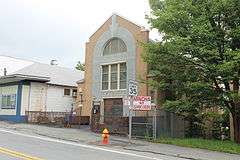
Ten Mile River Baptist Church |
Upload image |
000000001997-05-09-0000May 9, 1997
(#97000422) |
NY 97, jct. with Cochecton Trnpk.
41°33′36″N 75°01′00″W / 41.56°N 75.016667°W / 41.56; -75.016667 (Ten Mile River Baptist Church) |
Tusten |
|
| 73 |
Town and Country Building |
|
000000002004-09-24-0000September 24, 2004
(#04001061) |
1 N Main St.
41°47′59″N 74°44′45″W / 41.799722°N 74.745833°W / 41.799722; -74.745833 (Town and Country Building) |
Liberty |
|
| 74 |
Tusten Stone Arch Bridge |
Upload image |
000000002000-07-27-0000July 27, 2000
(#00000839) |
Tusten Rd. at Ten Mile River
41°33′22″N 75°01′10″W / 41.556111°N 75.019444°W / 41.556111; -75.019444 (Tusten Stone Arch Bridge) |
Tusten |
|
| 75 |
Valleau Tavern |
|
000000001992-11-27-0000November 27, 1992
(#92001599) |
Jct. of Co. Rd. 114 and NY 97
41°42′37″N 75°03′16″W / 41.710278°N 75.054444°W / 41.710278; -75.054444 (Valleau Tavern) |
Cochecton |
|
| 76 |
Woodbourne Reformed Church Complex |
|
000000002003-11-07-0000November 7, 2003
(#03001120) |
NY 42
41°45′42″N 74°36′00″W / 41.761667°N 74.6°W / 41.761667; -74.6 (Woodbourne Reformed Church Complex) |
Woodbourne |
|


_Town_Hall%2C_1929.jpg)