Oliveri
For other uses, see Oliveri (disambiguation).
| Oliveri | |
|---|---|
| Comune | |
| Comune di Oliveri | |
 Oliveri Location of Oliveri in Italy | |
| Coordinates: 38°7′N 15°4′E / 38.117°N 15.067°ECoordinates: 38°7′N 15°4′E / 38.117°N 15.067°E | |
| Country | Italy |
| Region | Sicily |
| Province / Metropolitan city | Province of Messina (ME) |
| Area | |
| • Total | 10.3 km2 (4.0 sq mi) |
| Elevation | 2 m (7 ft) |
| Population (Dec. 2004) | |
| • Total | 2,076 |
| • Density | 200/km2 (520/sq mi) |
| Time zone | CET (UTC+1) |
| • Summer (DST) | CEST (UTC+2) |
| Postal code | 98060 |
| Dialing code | 0941 |

The tongue of sand in Oliveri is where the lagoons of Tindari are located.
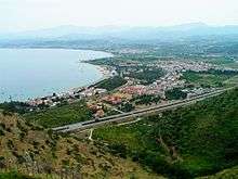
Oliveri panorama taken from the hill of Tindari
Oliveri (Sicilian: Uliveri) is a comune (municipality) in the Province of Messina in the Italian region Sicily, located about 150 kilometres (93 mi) east of Palermo and about 45 kilometres (28 mi) west of Messina. As of 31 December 2004, it had a population of 2,076 and an area of 10.3 square kilometres (4.0 sq mi).[1]
Oliveri borders the following municipalities: Falcone, Montalbano Elicona, Patti.
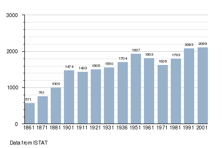
Demographic evolution
References
This article is issued from Wikipedia - version of the 6/21/2015. The text is available under the Creative Commons Attribution/Share Alike but additional terms may apply for the media files.